Thursday, September 18th, 2008...3:02 pm
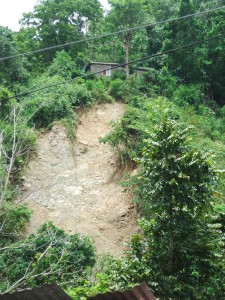
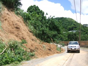
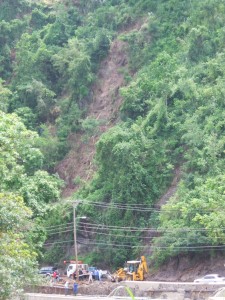
Effects of rainfall associated with tropical storm Gustav…
Mona Geoinformatics Institute and Unit for disaster Studies, in the company of Dr. Parris Lyew-Ayee and Mr. Luke Buchanan, carried out post-storm surveys from August 30 to September 2, 2008 in St. Andrew, Jamaica in areas affected by tropical storm Gustav in the company of. This is a summary of our field observations and responses to these hazards.

Tropical storm Gustav affected the island of Jamaica during 28 to 29 August 2008. Data released by the Meteorological Service of Jamaica has provided information on rainfall from some of their recording stations. In the parish of St. Andrew, the maximum rainfall, 290.00mm, was recorded from the Lawrence Tavern station on August 28. The Norbrook station was next with 126.5mm. The rainfall from Gustav triggered widespread damage via a number of landslides.
Rainfall-induced landslides, debris flows and mud flows, were common through out the eastern section of the island in the parishes of Portland, St. Thomas, Kingston and St. Andrew, and St. Mary.
The consequences are as follows:
Disruption of the road network
Stranded communities
Loss of income
Closed schools
Substantial damage to property and community facilities
The trauma of evacuation, leading to the disruption of the social fabric of many communities
Destruction of the domestic water supply
Loss of productive agricultural areas
Landslides added sediment to many river drainages raising channel levels thus increasing the risks of widespread flooding. Also, many areas will remain prone to landslides from future periods of sustained heavy rainfall.
Why do landslides occur? What should societies response landslides be?
Landslides and floods account for most of the natural disasters that have occurred on the island during the last decade. They continue to present common risks to life and property. These hazards are important because of their frequency, associated loss of life, disruption of socio-economic activities and their effect on the artificial and natural environment.
Landslides and floods are deeply interlinked. It is unfortunate that most of the damage resulting from landslides is ascribed to flooding. The strategies to deal with the two processes are different.

Jamaica’s terrain
Jamaica’s mountainous terrain, its geology, its fractured, altered and deeply weathered bedrock, its abundance of poorly consolidated sediments (colluviam) on hill slopes, its high precipitation due to its geographic location in belt of tropical storms, its geophysical location astride the seismically active plate boundary fault zone, all combine to make the island particularly susceptible to landslides.
What are debris flows?
Some landslides move slowly and cause damage gradually, whereas others move so rapidly that they can destroy property and take lives suddenly and unexpectedly. Debris flows (also referred to as mudslides, mudflows, or debris avalanches) are a common type of fast-moving landslide that generally occur during periods of intense rainfall on water-saturated soil. They usually start on hillsides as soil slumps or slides that liquefy and accelerate to speeds as great as 35 miles per hour (56 km/hour) or more. They continue flowing down hills and into channels and deposit sand, mud, boulders, and organic material onto more gently sloping ground. Their consistency ranges from watery mud to thick, rocky mud (like wet cement), which is dense enough to carry boulders, trees, and cars. Debris flows from many different sources can combine in channels, where their destructive power may be greatly increased (Reference: Landslide hazard Fact Sheets, U.S. Geological Survey).

Land use in Jamaica
Over the last four decades the economy of Jamaica has expanded from an agricultural base to one that relies heavily on tourism, manufacturing, mining and diverse services. As a consequence, land use in Jamaica is changing rapidly in order to meet the economic and housing needs of the populace who must utilise hazard-prone, geologically young landforms and steep slopes.
Unfortunately, human actions often increase the risk of landslides by modifying the landscape, building on unstable slopes or in the path of potential landslides. Given the ever-increasing toll from landslides and sediment floods, it appears that many of us are completely unaware of our exposure to landslide risk.
It is not unreasonable to argue that the frequency of urban landslides in Jamaica is a consequence of changing land use.
However, by understanding the scientific nature of the hazard, its demographic impacts, and learning from the past disasters and following the axiom ‘the present is key to the future’, we may be able to protect ourselves from the effects of landslides.
From Gustav, most of the damage is related to landslide processes and sediment floods.
Looking at the pictures of the damage in the urban areas in the media, one gets the impression that incredible amounts of rainfall took place. However, the maximum rainfall that has been reported so far in eastern Jamaica is of the order of 290mm on August 28, 2008. Is our urban landslide and flooding problem related to a lack of understanding of hazardous processes? All possible land is being covered with concrete and tarmac thus preventing the soaking of water into the ground. The trick is the management of landslides, runoff and sediment floods.

A state-of-the-art Natural Hazard Locator System developed by Mona Geoinformatics Institute at UWI, Mona is able to provide information on hazardous areas and societal vulnerabilities. However, this pro-active project requires financial support to expand its operational capabilities and availability to the wider society. Our vision is for every Jamaican to be able to know their natural hazard.
Click the links for additional information:
Following link provides information on landslides in Jamaica.
This is a graphic illustration of damage induced by rainfall in Jamaica
-Rafi Ahmad
Leave a Reply