August 28th, 2008
Tropical Storm Number Eight formed this morning over the central Caribbean Sea, south of Hispaniola.
At 7.00 a.m. the centre of Tropical Depression Number Eight was located near latitude 19.8 degrees North and longitude 57.9 degrees West, or about 575 kilometres east- northeast of the northern Leeward Islands.
The Depression is moving toward the west- northwest at nearly 8 km/h and a turn to the northwest is expected later today. On the track the Depression will be passing well north of the Leeward Island during the next 24 hours.
Maximum sustained winds are near 55 km/h, with higher gusts. The Depression has the potential to become a Tropical storm later today or Friday.
August 28th, 2008
With the island still under a Tropical Storm Warning and a Hurricane Watch associated with Tropical Storm Gustav, the Office of Disaster Preparedness and Emergency Management (ODPEM) is advising the public of the following telephone numbers for the National Emergency Operations Centre (NEOC) and the Parish Emergency Operation Centres (PEOC)
Area of operation Parish Telephone Number
ODPEM Switchboard Kingston 928-5111/4
ODPEM Switchboard Kingston 938-2525/6
ODPEM Switchboard Kingston 938-2550/1
EOC Straight line Kingston 930-0660/1
ODPEM Digiline Kingston 618-5637/44
St. Ann EOC St. Ann 794-9331/2972-2373972-2615/6
St. Mary EOC St. Mary 994-2178
St. Thomas EOC St. Thomas 982-9449982-9366982-2227
St. Elizabeth EOC St. Elizabeth 965-2256965-2267
St. James EOC St. James 952-5500
Trelawny EOC Trelawny 954-3228954-3970
Westmoreland EOC Westmoreland 955-2655955-2798
Hanover EOC Hanover 956-2236956-2947956-2305956-2173
Manchester EOC Manchester 962-2278/9
Clarendon EOC Clarendon 986-2216986-2234
St. Catherine EOC St. Catherine 984-3111/2
Portland EOC Portland 993-2665993-2765
Portmore EOC St. catherine 740-0789740-7440/2
August 28th, 2008
As the island prepares for the possible effects of Tropical Storm Gustav, the Office of Disaster Preparedness and Emergency Management (ODPEM) will open Emergency Shelters at the following locations at 3.00 a.m. today.
St. Ann
1. Concord Catholic Church
2. Ocho Rios High School
3. St. Ann’s Bay Primary School
4. Steer Town Primary and Junior High School
St. Mary
1. Mount Joseph Primary School
2. Port Maria S.D.A Church
3. Baxter Mount Primary School
4. Enfield Primary and Junior High school
5. Port Maria High School
6. Annotto bay High School
Portland
1. Windsor All Age School
2. Comfort Castle Primary and Junior High School
3. Fellowship Primary and Junior High School
4. Norwich Primary School
5. Titchfield High School
6. Salvation Army Church Port Antonio
Procedures for Registration Centres
The ODPEM through its National Disaster Welfare Response Programme is advising the public that it will be initiating a new system for assessment of the impact of affected persons and determination of beneficiaries for government welfare scheme. The following steps outline the procedure that will govern welfare assistance:
1. Schools will remain the primary registration centre for individuals or families affected
2. Within a day or two after the impact the ODPEM and the Met Office will give the all clear signal
3. Registration will commence after the all clear signal and will run for approximately three (3) days
4. The list of persons assessed will be verified against the Program for Advancement Through Health and Education (PATH); National Council for Senior Citizens; Combined Disabilities Association; Rural Agricultural Development Authority; and Fisheries Division programmes.
August 28th, 2008
As Tropical Storm Gustav become more organised, the Met Office has replaced the Hurricane Warning for the entire island with immediate effect. A hurricane warning means that dangerous conditions could be experienced within the next 24 hours or less, these conditions include: high winds, flood producing rains and storm surges.
The public is being advised to treat the situation seriously, as the current path will see the storm moving along Jamaica’s South Coast, resulting in widespread impact.
Hurricane Safety Tips
The public is being urged to continue monitoring radios and televisions for further advisories and to avoid areas that are at risk from flooding and landslides. Also take the following precautions in the event of heavy rains:
1. Avoid flooded waterways, gullies, streams or rivers, either on foot or in vehicles.
2. Be ready to evacuate if you live in low-lying or flood-prone areas.
3. Decide on likely evacuation routes now. Plan to stay with family or friends in safer areas or in a public shelter and move to safety.
4. Wrap important personal items, family documents, and electrical appliances in plastic bags and store away from the reach of floodwaters.
5. All small craft operators, including fishers from the cays and banks, are advised to secure their vessels and remain in safe harbour until all warning messages have been lifted and wind and sea conditions have returned to normal.
The National Emergency Operations Centre (NEOC), headquartered at the ODPEM’s offices at 12 Camp Road, Kingston 4, continues to be activated and closely monitoring the progress of Tropical Storm Gustav.
August 27th, 2008
Tropical Storm Gustav has further weakened just west of Haiti; however, a Tropical Storm Warning and a Hurricane Watch remain in effect for Jamaica. This means that hurricane conditions still pose a possible threat while tropical storm conditions are expected to affect the island in 24 hours or less.
At 7:00 p.m. the centre of Tropical Storm Gustav was located near latitude 19.0 degrees North and longitude 75.0 degrees West; about 170 km (105 miles) northeast of Morant Point, Jamaica, or 100 km (65 miles) south of Guantanamo, Cuba.
Gustav is moving westward at about 11 km/h (7 mph) and this general motion is expected to continue during the next 24 hours.
Maximum sustained winds have decreased to 75 km/h (45 mph), with higher gusts, and slow strengthening is forecast tonight and tomorrow. Tropical storm force winds extend up to 85 km (50 miles) from the centre.
On its forecast track, the centre of Tropical Storm Gustav will gradually strengthen while passing between Cuba and Jamaica tomorrow. Heavy rainfall and strong winds are projected to spread across the island tonight, through the day tomorrow and into Friday, especially over northern parishes. Storm surge flooding of 1-2 metres is also likely over northern coastal areas.
All small craft operators, including fishers from the cays and banks, are advised to remain in safe harbour until all warning messages have been lifted and wind and sea conditions have returned to normal.
All interests should continue to listen to subsequent News Releases from the Meteorological Service. The next Bulletin will be issued at 11:00 p.m.
August 27th, 2008
Today the Gleaner travelled around Jamaica to see how prepared Jamaica is with the coming of Hurricane Gustav…
Work to be done….
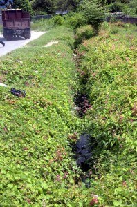
This drain in Hamilton Gardens, St. Catherine is covered with vegetation. Image by Norman Grindley /Deputy Chief Photographer.

This Gully on Industrial Terrace is in need of cleaning. Image by Junior Dowie / Staff Photographer.

The Duhaney river is rising near to several homes in New Heaven, St. Andrew. Image by Norman Grindley /Deputy Chief Photographer.

The Duhaney river is rising near to several homes in New Heaven, St. Andrew. Image by Norman Grindley /Deputy Chief Photographer.
Work underway…
 A tractor driver loads a truck with mud and garbage from the Waterford main drain during a gully cleaning exercise in Portmore. Image by Norman Grindley /Deputy Chief Photographer.

Mayor of Kingston, Desmond McKenzie third right with the press and members of his party watch clean up begins on Maiden Lane. Image by Junior Dowie / Staff Photographer.

Workmen from the KSAC clear blocked drains along Harbour Street in Kingston. Image by Norman Grindley/Deputy Chief Photographer.
If you have any pictures you would like to share email them to us at pics@gleanerjm.com
August 27th, 2008
A Tropical Storm Warning and a Hurricane Watch remain in effect for Jamaica, even as a weakened Tropical Storm Gustav moves closer to Jamaica. This means that hurricane conditions still pose a possible threat while tropical storm conditions are expected to affect Jamaica in 24 hours or less.
At 4:00 p.m. the centre of Tropical Storm Gustav was located near latitude 19.1 degrees North and longitude 74.4 degrees West; about 230 km (140 miles) northeast of Morant Point, Jamaica, or 150 km (90 miles) southeast of Guantanamo, Cuba.
Gustav is drifting west-northwestward at about 6 km/h (4 mph) and this general motion is expected to continue through tonight with a gradual increase in forward speed.
Maximum sustained winds are nearly 85 km/h (50 mph), with higher gusts, and slow strengthening is forecast tonight and tomorrow. Tropical storm force winds extend up to 85 km (50 miles) from the centre.
On its forecast track, the centre of Tropical Storm Gustav will continue to move away from Haiti this evening and then pass between Cuba and Jamaica tomorrow. Outer bands of the storm could affect Jamaica with scattered showers and gusty winds this evening; however, heavy rainfall and strong winds are projected to spread across the island later tonight and through the day tomorrow, especially over northern parishes.
All small craft operators, including fishers from the cays and banks, are advised to remain in safe harbour until all warning messages have been lifted and wind and sea conditions have returned to normal.
All interests should continue to listen to subsequent News Releases from the Meteorological Service. The next Bulletin will be issued at 8:00 p.m. today.
August 27th, 2007

Photo submitted by reader Kerry-Ann Chen: Damage caused to Portmore Fishing Village by Hurricane Dean
Dear reader …
In continuing our coverage of Hurricane Dean The Gleaner and Go-Jamaica are continuing to publish your photographs of the storm and its aftermath.
Contributions are continuing to arrive, which we expect to increase, given that many people have photographs that they were initially unable to send since they lacked light or Internet access.
If that describes you, and you are now ready to contribute, then simply e-mail your photographs to hurricanepix@gleanerco.net or simply register for the blog and upload your own content, complete with captions/stories.
Remember to provide your name and descriptions of your photographs so that we may properly credit and caption them. Also, include your contact details, which we will keep private, will help us to clarify any information in your submission and to stay in touch.
Thanks in advance
The Go-Jamaica team
P.S. Worth a look is the Flickr page of blogger ‘Bonita Jamaica’, which has 147 Dean-related photographs
August 23rd, 2007
 Click here to listen to Power 106 FM online
Power 106FM will be conducting a series of community sessions lasting seven days, beginning in Morant Bay on Friday August 24
On Monday the show will travel to Portland Cottage.
The show will be hosted by Michael Cuffe and the discussion will take place between 2:30 p.m. and 5 p.m.
Persons residing overseas can use the Power 106FM freephone numbers.
These numbers are courtesy of Jamaica National Building Society…
United Kingdom
Line 1: 020 7708 6670
Line 2: 020 7708 6672
United States
Line 1: 954 535 5761
Line 2 954 535 5762
This numbers is courtesy of People’s Telecom …
Toll free number
1 866 546 5106
August 23rd, 2007

Ross Sheil, Gleaner Online Editor
“Imagine…you’re a relief worker with a truck full of emergency supplies, trying to find those most in need. But which roads are open? Which hospitals are still standing? How do you reach the people needing help?”
… so says a website for the charity Map Action (above) which travels to disaster zones and provides assessments with the intention of informing donors and individuals where to send funds.
So donors – if you are reading this – a team from Map Action are currently in Jamaica. Click here to learn more about their assessment of the island post-Hurricane Dean.
Meanwhile another useful website is that of the Cuban Metereological Service. The site is written in Spanish but you can translate the content by simply dragging the URL into Google Language Tools.


 Click here to listen to Power 106 FM online