September 20th, 2008

Public Service Announcement: Motorists warned not to cross Grants Pen Fording

The Police are warning motorists not to attempt to cross the Grants Pen Fording in St. Andrew.

Motorists are being urged to use alternative routes.

Jamaica is currently under a flash flood warning.

A flash flood watch means flash flooding is possible and residents are advised to take precautionary measures and to keep informed by listening to further releases from the meteorological service.

The Met Office said the active Tropical Wave that has been in the vicinity of Jamaica will continue to influence the weather conditions across the island.

September 19th, 2008

Flash Flood Watch remains in effect for Jamaica

The Meteorological Service has extended the Flash Flood Watch for low-lying and flood-prone areas of all parishes, until 5.00 p.m. today.
 
Flash Flood watch means flash flooding is possible and residents are advised to take precautionary measures, keep informed by listening to further releases from the Meteorological Service and be ready for quick action if flooding is observed or if a Warning is issued.

The very active Tropical Wave that has been in the vicinity of Jamaica will continue to influence weather conditions, as it begins to drift westward, across the central Caribbean, today.
 
The system continues to produce an area of instability over the island, therefore periods of moderate to heavy thundershowers and gusty winds should be expected over all parishes.  As a result, flash flooding is likely over low-lying and flood prone areas during the next 12 to 24 hours.
 
Marine interests, especially fishers on the cays and banks, should continue to exercise caution as gusty winds and choppy seas may be encountered in the vicinity of thunderstorms.

September 18th, 2008

Effects of rainfall associated with tropical storm Gustav…

Mona Geoinformatics Institute and Unit for disaster Studies, in the company of Dr. Parris Lyew-Ayee and Mr. Luke Buchanan, carried out post-storm surveys from August 30 to September 2, 2008 in St. Andrew, Jamaica in areas affected by tropical storm Gustav in the company of. This is a summary of our field observations and responses to these hazards.


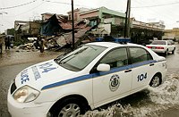
Tropical storm Gustav affected the island of Jamaica during 28 to 29 August 2008. Data released by the Meteorological Service of Jamaica has provided information on rainfall from some of their recording stations. In the parish of St. Andrew, the maximum rainfall, 290.00mm, was recorded from the Lawrence Tavern station on August 28. The Norbrook station was next with 126.5mm. The rainfall from Gustav triggered widespread damage via a number of landslides.

Rainfall-induced landslides, debris flows and mud flows, were common through out the eastern section of the island in the parishes of Portland, St. Thomas, Kingston and St. Andrew, and St. Mary.
The consequences are as follows:
Disruption of the road network
Stranded communities
Loss of income
Closed schools
Substantial damage to property and community facilities
The trauma of evacuation, leading to the disruption of the social fabric of many communities
Destruction of the domestic water supply
Loss of productive agricultural areas
Landslides added sediment to many river drainages raising channel levels thus increasing the risks of widespread flooding. Also, many areas will remain prone to landslides from future periods of sustained heavy rainfall.

Why do landslides occur? What should societies response landslides be?
Landslides and floods account for most of the natural disasters that have occurred on the island during the last decade.  They continue to present common risks to life and property. These hazards are important because of their frequency, associated loss of life, disruption of socio-economic activities and their effect on the artificial and natural environment.
Landslides and floods are deeply interlinked. It is unfortunate that most of the damage resulting from landslides is ascribed to flooding. The strategies to deal with the two processes are different.

Jamaica’s terrain
Jamaica’s mountainous terrain, its geology, its fractured, altered and deeply weathered bedrock, its abundance of poorly consolidated sediments (colluviam) on hill slopes, its high precipitation due to its geographic location in belt of tropical storms, its geophysical location astride the seismically active plate boundary fault zone, all combine to make the island particularly susceptible to landslides.

What are debris flows?
Some landslides move slowly and cause damage gradually, whereas others move so rapidly that they can destroy property and take lives suddenly and unexpectedly. Debris flows (also referred to as mudslides, mudflows, or debris avalanches) are a common type of fast-moving landslide that generally occur during periods of intense rainfall on water-saturated soil. They usually start on hillsides as soil slumps or slides that liquefy and accelerate to speeds as great as 35 miles per hour (56 km/hour) or more.  They continue flowing down hills and into channels and deposit sand, mud, boulders, and organic material onto more gently sloping ground. Their consistency ranges from watery mud to thick, rocky mud (like wet cement), which is dense enough to carry boulders, trees, and cars. Debris flows from many different sources can combine in channels, where their destructive power may be greatly increased (Reference: Landslide hazard Fact Sheets, U.S. Geological Survey).

Land use in Jamaica
Over the last four decades the economy of Jamaica has expanded from an agricultural base to one that relies heavily on tourism, manufacturing, mining and diverse services. As a consequence, land use in Jamaica is changing rapidly in order to meet the economic and housing needs of the populace who must utilise hazard-prone, geologically young landforms and steep slopes.
Unfortunately, human actions often increase the risk of landslides by modifying the landscape, building on unstable slopes or in the path of potential landslides. Given the ever-increasing toll from landslides and sediment floods, it appears that many of us are completely unaware of our exposure to landslide risk.
It is not unreasonable to argue that the frequency of urban landslides in Jamaica is a consequence of changing land use.

However, by understanding the scientific nature of the hazard, its demographic impacts, and learning from the past disasters and following the axiom ‘the present is key to the future’, we may be able to protect ourselves from the effects of landslides.

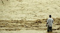
From Gustav, most of the damage is related to landslide processes and sediment floods.
Looking at the pictures of the damage in the urban areas in the media, one gets the impression that incredible amounts of rainfall took place. However, the maximum rainfall that has been reported so far in eastern Jamaica is of the order of 290mm on August 28, 2008. Is our urban landslide and flooding problem related to a lack of understanding of hazardous processes? All possible land is being covered with concrete and tarmac thus preventing the soaking of water into the ground. The trick is the management of landslides, runoff and sediment floods.

A state-of-the-art Natural Hazard Locator System developed by Mona Geoinformatics Institute at UWI, Mona is able to provide information on hazardous areas and societal vulnerabilities. However, this pro-active project requires financial support to expand its operational capabilities and availability to the wider society. Our vision is for every Jamaican to be able to know their natural hazard.

Click the links for additional information:

Following link provides information on landslides in Jamaica.

This is a graphic illustration of damage induced by rainfall in Jamaica

-Rafi Ahmad

September 17th, 2008

A new respect for tropical storms

Gustav was a very interesting storm that provided a stark reminder to all of us that the damage potential of tropical storms should not be under-estimated.

Many Jamaicans assumed that Gustav was not worth taking seriously because of its classification as weaker than a minimal hurricane.  However, its bite was a lot worse than its bark!

The unfortunate reality is that tropical storms and hurricanes are classified by the depth of their central pressure and the resulting strength of their winds; not by the extent of their rain bands or their flood potential.  Maybe another scale ought to be devised.  Ironically, tropical systems that have affected Jamaica in the past have caused more loss of life due to the rain factor than the wind factor.

I am sure that in the future we will take notes of those spiral bands, or outer bands, that are constantly referred to in the Met Office Bulletins.  Most of the “punch” in Tropical Storm Gustav came from these swirling bands behind the centre of the system.  They produced severe thunderstorms and violent rain along with strong gusts of wind, albeit these gusts seemed to be a lot less consequential.

The older ones among us would have recalled the effects of other Tropical Storms like Florence in 1953 and Gilda in 1973; floods that have etched their names in our memories for a long time to come.  Wilma in 2005 and Noel in 2007 are also among that number, and Gustav now joins that esteemed list.

September 12th, 2008

Police Assist Residents

The police force assists residents of McGregor Gully.

September 12th, 2008

Hurricane Gilbert – 20th Anniversary

Today marks the 20th anniversary of Hurricane Gilbert. For most Jamaicans, Hurricane Gilbert was the worst hurricane to hit Jamaica since “ ’The 51 storm”. For some, recalling the events of this notorious hurricane may bring back bitter sweet memories. For those who died, with their loved ones, their memories still live on.


A tropical wave that was exiting the African coastline on September 3 developed into the 12th tropical depression of the season on September 8, while approaching the Windward Islands. The cyclone rapidly strengthened to hurricane status on September 10, as a west-northwest motion brought Gilbert into the eastern Caribbean Sea. Gilbert passed directly over Jamaica on September 12 as a major hurricane, becoming the first direct impact for the island from a hurricane since 1951.

Winds gusted to nearly 150 mph as Gilbert produced a 9-foot storm surge along Jamaicas northeast coast. Jamaica was devastated as the eyewall traversed the entire length of the island. During this period the eye contracted from 25 nmi to only 12 nmi upon exiting Jamaica.

Gilbert emerged off the western coastline of Jamaica and began a period of extraordinarily rapid intensification. The ferocious hurricane strengthened to Category 4 status as its northern eyewall pounded Grand Cayman Island with 155 mph wind gusts early on September 13.

Gilberts remarkable intensification trend continued as the cyclone reached Category 5 status on the afternoon of the 13th and eventually reached peak winds of 185 mph. The minimum central pressure of the cyclone plummeted to 888 millibars, which represented a 70-millibar drop in only a 24-hour period. This minimum central pressure recorded by NOAA aircraft remains the lowest pressure ever recorded in the western hemisphere.

Gilbert crossed the northeast coast of Mexico’s Yucatan Peninsula on September 14, becoming the first Category 5 hurricane in the Atlantic basin to strike land since Camille in 1969.

Gilbert weakened over the Yucatan Peninsula and emerged into the western Gulf of Mexico as a Category 2 hurricane. Gilbert’s large circulation regained major hurricane status as the cyclone continued on a west-northwest course on the 16th. The hurricane made its final landfall near the town of La Pesca on the Mexican Gulf Coast on the evening of September 16 as a strong Category 3 hurricane.

Gilberts remnants spawned 29 tornadoes over Texas on September 18, with flooding spreading to the Midwest as the remnants merged with a frontal boundary over Missouri on September 19. Although no reliable measurements of storm surge exist from Gilbert’s two Mexican landfalls, estimates are that Gilbert produced between 15 and 20 feet of surge along the Yucatan and eight to 13 feet at landfall in mainland Mexico.

Gilberts large size and impacts were felt over much of the Caribbean, Central America as well as portions of the United States. The death toll of 318 gives an idea of the scope of Gilbert’s impacts: Mexico 202, Jamaica 45, Haiti 30, Guatemala 12, Honduras 12, Dominican Republic 5, Venezuela 5, United States 3, Costa Rica 2, and Nicaragua 2.

The deaths from Costa Rica, Guatemala, Honduras, Nicaragua, and Venezuela were caused by inland flash flooding from outer rainbands.

Source: http://en.wikipedia.org/wiki/Hurricane_Gilbert

September 11th, 2008

Remembering Ivan – September 10 -12, 2004


On September 10-12, 2004, the centre of Ivan passed near Jamaica, causing significant wind and flood damage. Looters were reported roaming the streets of Jamaica’s capital city, Kingston (which appeared deserted), robbing emergency workers at gunpoint. Overall, 17 people were killed in Jamaica and 18,000 people were left homeless as a result of the flood waters and high winds. Most of the major resorts and hotels fared well, though, and were reopened only a few days after Ivan had passed. Damage on Jamaica totaled US$360 million.  


Like an avalanche, hurricane ‘IVAN’ made its way across the Caribbean waters aiming directly at Jamaica. Through divine intervention, it shifted a wee bit, dropped back from a category five to a category four hurricane, broke its wind-speed to eight miles an hour and ‘coasted’ on the shore as it battered the land with puffs of gusting winds and torrential showers of rain.

Manchester, St Elizabeth and Clarendon had not yet recovered from the ravishing of Charley Two before they were again struck by this destroyer. Right across the parishes- from north to south; east to west, everyone experienced the wrath of IVAN the terrorist. One resident remarked, “Don’t say IVAN, say ‘MASS’ Ivan; him a nuh boy, him a big man!”


  Police patrol a street in Kingston after Hurricane Ivan hit Jamaica, September 11, 2004.

 A Jamaican man stands on a flooded street in Kingston during rain and winds brought on by Hurricane Ivan in Kingston, Jamaica, September 11, 2004.

Deadly Hurricane Ivan ripped into Jamaica with powerful winds, torrential rains and huge waves, tearing away houses and washing out roads before heading toward the tiny Cayman Islands and Cuba.


One man said, “I heard this roaring sound coming up the hill and suddenly, I did not hear it again. I peeped outside, and noticed the rain and breeze going down hill. Just as I was about to say, ‘Thank God’, I heard a whistling sound coming back. Before I could think what it was, my roof was flying down the hill while the whistle continued up the hill.”

He explained this phenomenon this way. “Ivan must have said that him never know sey one house left up yah suh. So him tun back dung de hill, pick up speed and whistle when him a go blow off mi roof. Bway dis yah storm nuh only rough, him cold!”

Ivan was steadfast in its focus…from its nook on the shore, it focused in all directions. Being able to ‘view’ the land from a strategic angle, it had no difficulty stalking its victims. Ivan was a good mixer too. No category was spared. No, not one! People have been heard to say, “dis yah storm nuh partial, eh touch everybody!”


Ann-Marie Burke and Madge Rochester were two women who lived in one of the beachfront houses that felt the full rage of Ivan. Madge said she thinks she was lucky that they evacuated on Thursday as there would have been more damages than just property.

When they returned on Monday they were shocked to see the wreckage Ivan left behind. It was as if something chewed its way through the community and spat it back out.

Ivan strength raised the waves to great heights, which bit huge chunks out of the buildings creating new entrances and exits. The ‘monster’ swooped down on the approximately three feet of seawall without any resistance and ravaged the houses sitting along the shoreline.

“Water and sand went through the grill at the front room but everything else was flushed out from the back,” said Madge. The waves that broke high tore off the doors leading into the house allowing a free-flow of water, sand and other debris to settle inside.

The beach to the rear of the house was dugout leaving behind large boulders never seen before. The foundation of the seawall that should be underground is now visible as it sits atop the sand.

In the kitchen of the house, there stood empty bottles of Bailey’s Rum Cream lining the top of the cupboard unharmed. Walks through the wrecked house led to three left-foot of shoes, no a sign of the right ones.

In the midst of all the damage, these residents manage to still have running water in their taps, more fortunate than many Jamaicans. Like some of the other residents of this area, Madge suffered additionally from looters who stole some of the appliances that once sat throughout the house.

They confessed that they have nowhere else to go and will stay there until better comes. When asked what do they eat, Madge was quite frank to say, “Biscuits and sodas.”

September 8th, 2008

Hope River Residents Marooned

Residents of Kintyre Close near to the Hope River speak to the Gleaner after the passage of Tropical Storm Gustav.

September 8th, 2008

Harbour View’s Bailey Bridge

The bridge that passes over the Hope River, in Harbour View was damaged as a result of the strong winds and rain associated with Tropical Storm Gustav.  However, Jamaican’s still went about their daily chores and to work, even before the Bailey Bridge was complete.

September 5th, 2008

Tracking Hanna, Ike & Joesphine…

There are currently three operating in the Caribbean region .  Tropical Storm Hanna,  Tropical Storm Josephine and Hurricane Ike (category 3).

Click here if you want to find out more about their possible impact – Tracking Hanna, Ike and Joesphine