August 30th, 2008

‘Star’ Coverage of Gustav

If you are in Jamaica or you have got family and friends in Jamaica do not miss today’s edition of the The STAR at a special price of $25.

In this special edition you will find the photos, the stories chronicling the passage of Tropical Storm Gustav.

If can’t get a copy today, remember you can contact the Gleaner Offices at 876-922-3400 to find out how you can get a copy later.

Also look out for the Financial Gleaner and the Gleaner’s Special Post-Olympic Supplement which will be available in a Jamaican location near you on Monday Morning. A little bit of the Supplement will be Online tonight so don’t miss it and look out for the link right here.

August 30th, 2008

Tropical Storm Warning Lifted

Finally the Tropical Storm Warning has been lifted. Jamaica now breathes a sigh of relief and the re-building can now begin. Hurricane Gustav is now a category 3 hurricane as at 7:00 a.m. EST.

For interest in the Cayman Islands, the eye is now to the North-West but the island was  and is still being affected by heavy winds and rains based on satellite imagery.

For the latest bulletin visit Go Jamaica Weather.

N.B. Remember if you have photos or stories to tell email us at Hurricanepix [at] gleanerco [dot] net.

August 29th, 2008

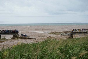
Reader’s Photograph of the Harbour View Bridge

Early Friday morning, August 29, 2008,  a section of the Harbour View Bridge collapsed as a result of the raging waters caused by the passage of Tropical Storm Gustav.

Here is a photo taken by Anna Overton, a Gleaner Online reader captured the damage. For more photos visit the Gallery

Damaged Harbour View bridge in St. Andrew. Photo taken from the Harbour View Library - Anna Overton

Damaged Harbour View bridge in St. Andrew. Photo taken from the Harbour View Library - Anna Overton

To get a perspective of where the Harbour View bridge is, look at read this story,
Harbour View Bridge collapses leaving residents stranded
and look for the map at the end. One perspective is clear, residents in St. Thomas are pretty much cut off from Kingston.

Remember to submit your photographs and stories to Hurricanepix@gleanerco.net

August 29th, 2008

Gustav damages banana industry

With a week to go before Banana export begins in Jamaica, farmers in St Mary are facing almost complete devastation after the passing of Tropical Storm Gustav.
Right across the parish, Banana trees were down but the plight of the farmers wasn’t the only problem St Mary residents had to face.

Rains started early Wednesday night and, accompanied by strong gusty winds, have since intensified.

According to Yolande Williams, disaster coordinator for the parish, all agencies were activated yesterday and were prepared in case of disaster.
There are currently five shelters opened with 63 occupants at this time.

The entire parish is without electricity. There were reports of boulders falling on the Junction road, though The National Works Agency has already put the necessary machinery in place to clear them.

That machinery will have to be working overtime, as since their movement into action, there have been numerous reports of landslides and fallen trees on the Junction road. There have also been reports of trees falling on power lines all across the parish.

The districts of Clonmel, Lewis Store and Highgate have all been cut off from neighbouring communities due to the collapse of the Westmoreland Bridge, while two houses in Broadgate have been swept away by the Wag Water River.

August 29th, 2008

Gustav and the Rio Minho give Clarendon a scare

Sections of Clarendon have begun to be adversely affected by the tail of Tropical Storm Gustav

This morning the Park Hall to Grantham main road in northern Clarendon was impassable after the waters of the Rio Minho River began to rise.

The Rio Minho continued to pose problems for Clarendonians as the Crooked River Bridge, which links the community of the same name to Trout Hall, was cut in two.

The main road from May Pen to Frankfield, which is also in northern Clarendon has also been deemed impassable and there was serious flooding in the Chapelton and Pennant areas.

In May Pen, there was flooding on the main road that leads to Manchester Avenue and Guinepp Tree, however, waters are now receding.

Four Paths is also flooded, which means persons coming from Mocho have had difficulties making their way to May Pen and other destinations.
The same story held true for Pleasant Valley, a community in May Pen, where four adults and 10 children were evacuated to the Pleasant Valley All-Age School.
Another shelter, Alley Primary is now housing 20 persons, while the Kemps Hill high School is holding 17.

Up to 12:30, Rocky Point residents were breathing a sigh of relief after being able to report minimal damage and minor flooding.
Some residents are still on the lookout though, as the rain hasn’t stopped just yet.

August 29th, 2008

View of Gustav

Amateur video of Tropical Storm Gustav shot from the offices of the Jamaica Gleaner Company Limited.

August 29th, 2008

Gustav claims lives

Furious tropical storm Gustav may have claimed at least 10 lives thus far, the Office of Disaster Preparedness and Emergency Management (ODPEM) have said.

Ronald Jackson told The Gleaner this morning that there are several reports of the loss of lives but the ODPEM has not been able to confirm the reports.

“We have unconfirmed reports that 10 people have died but of that number we have found only one body,” Jackson said.

Two deaths have been reported in Gordon Town, St. Andrew. There are also reports of one death in Llandewey, St Thomas, where a man was washed away in a car. A search has been launched for a female victim.

Prime Minister Bruce Golding, who is head of the national disaster committee, said on radio today that there are reports of at least 11 deaths in the country.

Meanwhile, ODPEM has reported that 1520 persons are in 76 emergency shelters. ODPEM has also reported extensive flooding over the eastern end of the island.

The meteorological service this morning said that although the centre of Gustav is about to move away from Jamaica, bands of showers extend 200 km east of the island. It said that periods of heavy rainfall and strong, gusty winds are should continue throughout today.

August 29th, 2008

Bog Walk Gorge Closed…

T.S. Gustav Continues to Bring Rain to Jamaica

The Water Resources Authority (WRA) is reporting that the Rio Cobre has reached its critical point, 11 feet and rising.

As such the Bog Walk Gorge is now closed to vehicular and pedestrian traffic. The Public is urged to avoid this potentially dangerous area.

The ODPEM advises all to continue monitoring radio and television stations for further advisories and to avoid areas that are at risk from flooding and landslides. Also take the following precautions in the event of heavy rains:

1.    Avoid flooded waterways, gullies, streams or rivers, either on foot or in vehicles.
2.    Be ready to evacuate if you live in low-lying or flood-prone areas.
3.    Decide on likely evacuation routes now. Plan to stay with family or friends in safer areas or in a public shelter and move to safety.
4.    Take the following with you if you must go to a shelter:
§    Blankets and extra clothing; Medication; 24 hours’ supply of non-perishable food and water and a can opener; toilet articles such as toilet tissue and soap; portable radio, flashlights and batteries; First Aid Kit.
5.    Wrap important personal items, family documents, and electrical appliances in plastic bags and store away from the reach of floodwaters.
6.    All small craft operators, including fishers from the cays and banks, are advised to secure their vessels and remain in safe harbour until all warning messages have been lifted and wind and sea conditions have returned to normal.

The National Emergency Operations Centre (NEOC), headquartered at the ODPEM’s offices at 12 Camp Road, Kingston 4, continues to be activated and closely monitoring the progress of T.S. Gustav.
August 29th, 2008

RAINS CONTINUE AS GUSTAV NEARS THE WEST END OF JAMAICA …

Hurricane Warning Remains in Effect

A Hurricane Warning remains in effect for Jamaica this morning as Tropical Storm Gustav continues westward along the south coast and approaches the western end of the island.

At 4:00 a.m. the centre of Tropical Storm Gustav was located near latitude 18.1˚N and longitude 78.1˚W.  This is about 20 km (15 miles) south of Savanna-La-Mar, Jamaica, or 355 km (220 miles) east-southeast of Grand Cayman.

Gustav is now moving towards the west-northwest at 13 km/h (8 mph) and a turn towards the northwest is forecast during the next day or two.  On this track, the centre of the storm is expected to begin moving away from Jamaica in the next 2-4 hours and move near or over the Cayman Islands later today.

Maximum sustained winds have decreased to 105 km/h (65 mph), with higher gusts, and strengthening is forecast, bringing Gustav to hurricane strength later today or tomorrow.  Tropical storm force winds now extend up to 220 km (140 miles) from the centre.

Satellite and radar imagery confirm that, although the centre of Gustav is nearing the western coast of Jamaica, bands of showers extend over 200 km (125 miles) east of the island.  Periods of heavy rainfall and strong, gusty winds are, therefore, forecast to continue across the country through today.  Extensive flash flooding is, therefore, expected over low-lying and flood-prone areas.  Storm surge flooding is also possible, mainly along southern coastal areas.

Small craft operators, including fishers from the cays and banks, are reminded to remain in safe harbour until warning messages are lifted and wind and sea conditions return to normal.

The next Bulletin on Tropical Storm Gustav will be issued at 8:00 a.m. today.

August 29th, 2008

T.S. Gustav Batters the Island

The Hurricane Warning issued by the National Meteorological Service remains in effect for Jamaica as rainfall associated with Tropical Storm Gustav pummels the island. Given the continuous rainfall that has been experienced, high levels of saturation is currently taking place resulting in extensive flooding across eastern parishes.

Reports:

Flooding:-
· The McGregor Gully in the Vineyard Town area has overflowed its bank resulting in widespread flooding in the area
· Sections of Deanery Road are currently experiencing flooding
· Reports of flooding in Real Avenue in Harbour have been received
· The communities of barbican and Havendale in St. Andrew are also reporting incidents of flooding

Landslide:-
· Landslides have been reported in Cooper’s Ridge and Gordon Town in Upper St. Andrew
· A dwelling place in Cornfield, Papine has been disjointed as a result of a landslide in the area
· 2 houses in the Tavern Drive area of Kintyre have been washed into the nearby river due to landslippage.

Actions:-
Agencies’ response is currently underway to rescue persons trapped in flooded communities.

Shelters:-
There are currently 44 opened shelters housing a total of 920 persons, predominantly in the parish of St. Thomas

The public is being urged to continue monitoring radios and televisions for further advisories and to avoid areas that are at risk from flooding and landslides. Also take the following precautions in the event of heavy rains:

1. Avoid flooded waterways, gullies, streams or rivers, either on foot or in vehicles.
2. Be ready to evacuate if you live in low-lying or flood-prone areas.
3. Decide on likely evacuation routes now. Plan to stay with family or friends in safer areas or in a public shelter and move to safety.
4. Take the following with you if you must go to a shelter:
§ Blankets and extra clothing; Medication; 24 hours’ supply of non-perishable food and water and a can opener; toilet articles such as toilet tissue and soap; portable radio, flashlights and batteries; First Aid Kit.
5. Wrap important personal items, family documents, and electrical appliances in plastic bags and store away from the reach of floodwaters.
6. All small craft operators, including fishers from the cays and banks, are advised to secure their vessels and remain in safe harbour until all warning messages have been lifted and wind and sea conditions have returned to normal.

The National Emergency Operations Centre (NEOC), headquartered at the ODPEM’s offices at 12 Camp Road, Kingston 4, continues to be activated and closely monitoring the progress of T.S. Gustav.