August 19th, 2007

Information lines for Jamaicans overseas

The Jamaica National Building Society (JNBS) has made available the following telephone lines so that persons living overseas can stay informed during the passage and aftermath of Hurricane Dean:

August 19th, 2007

Take these precautions – ODPEM

The Office of Disaster Preparedness and Disaster Management (ODPEM) is advising Jamaicans to take the following steps while the Hurricane Warning remains in effect:

1. Stay tuned to the news and weather reports and listen out for emergency instructions, if any should be given.

2. Remain calm. Do not panic. Your ability to act logically is important during stressful events like a hurricane.

3. Wrap important documents such as passports, deeds and titles, birth certificates, ID cards, insurance policies in plastic and take them with you.

4. Ensure that adequate water is stored for domestic purposes.

5. Move furniture away from windows.

6. Check your arrangements for household pets. If you have made arrangements for them to be kept elsewhere, take them there now. If they are staying with you, make sure they have adequate food and water.

7. If your roof should come off and if the house or building shows signs of breaking up get in the closet or the bathtub and pull the mattress over your body for protection.

8. If you are away from home remain where you are until the storm has passed. Many people lose their lives trying to get from place to place during a hurricane.

9. There will be a brief period of calm weather. This is called the eye of the hurricane. It usually lasts for only a short while – from a few minutes to half and hour or more – and the winds return from the opposite direction. Please do not be fooled into thinking that the storm is over. Remain inside.

August 18th, 2007

Dean approaching Jamaica, tracking south

1811pm.jpg

From the Met Service …

August 18, 2007 @ 11:00 p.m.

BULLETIN No. 12

*** HURRICANE WARNING REMAINS IN EFFECT… FORECAST TRACK ADJUSTED SOUTHWARD***

The HURRICANE WARNING for Jamaica remains in effect as Hurricane Dean continues to approach Jamaica. This means that dangerous effects of a hurricane are expected to affect Jamaica in 24 hours or less.

At 10:00 p.m. the centre of Hurricane Dean was located near Latitude 16.2 degrees North, Longitude 71.7 degrees West. This is about 275 km (170 miles) south-southeast of Port-au-Prince, Haiti, or 530 km (330 miles) east-southeast of Morant Point, Jamaica.

Dean is moving towards the west-northwest near 28 km/h (17 mph) and a general west to west-northwestward motion is expected during the next 24 hours.

Maximum sustained winds have decreased slightly to near 230 km/h (145 mph), with higher gusts, and fluctuations in strength are likely during the next 24 hours. Hurricane force winds extend outward approximately 95 km (60 miles), while tropical storm force winds extend 335 km (205 miles) from the centre.

The forecast track has been adjusted to move the centre of Hurricane Dean over the waters south of Haiti on Sunday morning and close to Jamaica’s southern coastline from Sunday afternoon and through the evening.

Outer bands of the hurricane could, however, start affecting the island early Sunday morning with periods of showers and gusty winds reaching near gale force. As Dean approaches the island, expect heavy rainfall to spread across the island with the potential for severe flash flooding and landslides. Storm surge flooding of 1.5-3 metres (7-9 feet) above normal tide levels along with large and dangerous battering waves can be expected near the centre of Dean, especially over southern coastal areas.

All interests should continue to monitor subsequent Releases from the Meteorological Service. The next Bulletin on Hurricane Dean will be issued at 5:00 a.m.

August 18th, 2007

Dean still heading for JA – NHC at 5 pm

dean185pm.jpg


From the United States’ National Hurricane Centre (NHC)

HURRICANE DEAN ADVISORY NUMBER 23
NWS TPC/NATIONAL HURRICANE CENTER MIAMI FL AL042007
500 PM AST SAT AUG 18 2007

…OUTER FRINGES OF HURRICANE DEAN LASHING THE SOUTH COAST OF
HISPANIOLA…

A HURRICANE WARNING REMAINS IN EFFECT FOR THE SOUTH COAST OF THE DOMINICAN REPUBLIC FROM BARAHONA WESTWARD TO THE HAITI-DOMINICAN REPUBLIC BORDER…AND FOR THE SOUTHWESTERN PENINSULA OF HAITI FROM THE HAITI-DOMINICAN REPUBLIC BORDER TO PORT-AU-PRINCE. A HURRICANE WARNING IS ALSO IN EFFECT FOR JAMAICA. A HURRICANE WARNING MEANS THAT HURRICANE CONDITIONS ARE EXPECTED WITHIN THE WARNING AREA WITHIN THE NEXT 24 HOURS. PREPARATIONS TO PROTECT LIFE AND
PROPERTY SHOULD BE RUSHED TO COMPLETION.

A TROPICAL STORM WARNING IS STILL IN EFFECT ALONG THE SOUTH COAST OF THE DOMINICAN REPUBLIC FROM CABO ENGANO WESTWARD TO BARAHONA…AND FOR COAST OF HAITI NORTH OF PORT-AU-PRINCE TO THE NORTHERN HAITI-DOMINICAN REPUBLIC BORDER. A TROPICAL STORM WARNING IS ALSO EFFECT FOR PORTIONS OF CUBA…FROM THE PROVINCE OF CAMAGUEY EASTWARD TO THE PROVINCE OF GUANTANAMO. A TROPICAL STORM WARNING MEANS THAT TROPICAL STORM CONDITIONS ARE EXPECTED WITHIN THE WARNING AREA WITHIN THE NEXT 24 HOURS.

A HURRICANE WATCH REMAINS IN EFFECT FOR THE CAYMAN ISLANDS. A HURRICANE WATCH MEANS THAT HURRICANE CONDITIONS ARE POSSIBLE WITHIN THE WATCH AREA…GENERALLY WITHIN 36 HOURS.

INTERESTS ELSEWHERE IN THE WESTERN CARIBBEAN…INCLUDING WESTERN CUBA AND THE YUCATAN PENINSULA…SHOULD CLOSELY MONITOR THE PROGRESS OF DEAN.

FOR STORM INFORMATION SPECIFIC TO YOUR AREA…PLEASE MONITOR PRODUCTS ISSUED BY YOUR LOCAL WEATHER OFFICE.

AT 500 PM AST…2100Z…THE EYE OF HURRICANE DEAN WAS LOCATED NEAR LATITUDE 16.1 NORTH…LONGITUDE 70.2 WEST OR ABOUT 455 MILES… 735 KM…EAST-SOUTHEAST OF KINGSTON JAMAICA AND ABOUT 165 MILES… 270 KM…SOUTH OF SANTO DOMINGO IN THE DOMINICAN REPUBLIC.

DEAN IS MOVING TOWARD THE WEST-NORTHWEST NEAR 18 MPH…30 KM/HR… AND THIS GENERAL MOTION IS EXPECTED TO CONTINUE DURING THE NEXT 24 HOURS. ON THIS TRACK…THE CORE OF THE HURRICANE WILL CONTINUE TO MOVE SOUTH OF HISPANIOLA TODAY AND WILL BE NEAR JAMAICA ON SUNDAY.

MAXIMUM SUSTAINED WINDS REMAIN NEAR 150 MPH…240 KM/HR…WITH HIGHER GUSTS. DEAN IS AN EXTREMELY DANGEROUS CATEGORY FOUR HURRICANE ON THE SAFFIR-SIMPSON HURRICANE SCALE. SOME FLUCTUATIONS IN INTENSITY ARE LIKELY DURING THE NEXT 24 HOURS.

HURRICANE FORCE WINDS EXTEND OUTWARD UP TO 70 MILES…110 KM…FROM THE CENTER…AND TROPICAL STORM FORCE WINDS EXTEND OUTWARD UP TO 230 MILES…370 KM. PUNTA CANA IN THE DOMINICAN REPUBLIC HAS BEEN EXPERIENCING TROPICAL STORM FORCE WIND GUSTS FOR THE PAST SEVERAL HOURS.

ESTIMATED MINIMUM CENTRAL PRESSURE IS 930 MB…27.46 INCHES.

STORM TOTAL RAINFALL AMOUNTS OF 5 TO 10 INCHES CAN BE EXPECTED OVER JAMAICA… WITH MAXIMUM AMOUNTS OF UP TO 20 INCHES POSSIBLE. AMOUNTS OF 4 TO 6 INCHES ARE POSSIBLE OVER SOUTHERN HAITI WITH MAXIMUM TOTALS OF 10 INCHES POSSIBLE. THE REMAINDER OF THE DOMINICAN REPUBLIC…HAITI AND EASTERN CUBA…COULD RECEIVE 2 TO 4 INCHES OF RAIN WITH MAXIMUM AMOUNTS UP TO 7 INCHES POSSIBLE. ADDITIONAL RAIN
ACCUMULATIONS OF 1 TO 2 INCHES ARE POSSIBLE OVER PUERTO RICO…WITH ISOLATED STORM TOTAL AMOUNTS OF 5 INCHES. THESE RAINS COULD CAUSE LIFE-THREATENING FLASH FLOODS AND MUDSLIDES.

COASTAL STORM SURGE FLOODING OF 7 TO 9 FEET ABOVE NORMAL TIDE LEVELS…ALONG WITH LARGE AND DANGEROUS BATTERING WAVES…IS POSSIBLE NEAR THE CENTER OF DEAN IN THE HURRICANE WARNING AREA.

REPEATING THE 500 PM AST POSITION…16.1 N…70.2 W. MOVEMENT TOWARD… WEST-NORTHWEST NEAR 18 MPH. MAXIMUM SUSTAINED WINDS…150 MPH. MINIMUM CENTRAL PRESSURE…930 MB.

AN INTERMEDIATE ADVISORY WILL BE ISSUED BY THE NATIONAL HURRICANE CENTER AT 800 PM AST FOLLOWED BY THE NEXT COMPLETE ADVISORY AT 1100 PM AST.

August 18th, 2007

Haiti prepares for Hurricane Dean

Sheree Bennett in Petionville Port-au-Prince, Haiti

2:30 p.m.

At 8 a.m., the sun was bright and the skies clear. It is only now, in the afternoon, that any sign of impending ‘mauvais temps’ (bad weather) has become evident. Even here in the hills of uptown Petionville, it is still only overcast with the slightest of winds.

Weather advisories were posted in the national papers yesterday. The storm is expected to pass over Haiti’s southern peninsula late Saturday evening into early Sunday morning.

The departments (regions) that are most threatened are: Le Sud, le Sud-Est, La Grande Anse and Les Nippes. For these areas, the hurricane is expected to bring storm-force winds, rough seas and a high probability of severe flooding in low-lying areas and erosion in much of the deforested interior.

As at noon on Saturday, the hurricane is expected to pass 50 kilometres south of the capital, Port-au-Prince.

The United Nations Mission for the Stabilization of Haiti (MUNISTAH) has been alerted and mobilised to assist government relief efforts if necessary.

Although this area, Petion-ville, will not bear the brunt of the hurricane, torrential rain is expected across the island. Preparations are slow on the ground. Meanwhile people, in this area, seem to be unperturbed.

Some institutions, like the World Bank have gone into full security mode since yesterday while other agencies and businesses are still operant. Some students of the Faculty of Social Science at the National University in Port-au-Prince are expected to report for an exam this afternoon.

Hotel Montana is still buzzing with activity. At 11 a.m., most radio stations were still playing music.

August 18th, 2007

Western Jamaica prepares for Dean

WESTERN BUREAU: As Hurricane Dean continues to take aim at Jamaica; emergency stakeholders and residents across western Jamaica were yesterday (Friday) fine-tuning preparations in the event that the weather system impacts the island.

Checks made in the five western parishes reveal that response teams had instituted several strategies to deal with eventualities.

Coordinator of the St. Elizabeth Parish Disaster Committee, Yvonne Morrison,  summoned councillors and agencies to an emergency meeting on Friday. The 100 shelters across the parish were reportedly ready to house evacuees.

Over in Hanover all its 39 emergency shelters have been prepared for the passage of Hurricane Dean – the first Atlantic hurricane of 2007.  Mayor of Lucea, Councillor Vasca Brown, was at press time trying to source a generator to service the Lucea Police Station and Emergency Operation Centre (EOC) at the Hanover Parish Council- both of which are in close proximity.

There were reports of traffic congestion with one lane roadways accommodating two lanes of motor vehicles in the town of Savanna-la-Mar. There were also a mad rush at several supermarkets, wholesales and hardware stores where supplies were depleted as residents braced for Hurricane Dean.

At an emergency meeting of the St. James Disaster Preparedness Committee, it was concluded that the parish is in an advanced state of preparedness for Hurricane Dean, with all essential services in place.

“The emergency support team has already reviewed evacuation routes; and individuals in communities with special needs for assistance have been identified,” said Suzzette Brown, public and community relations officer at the council.

“In furtherance of its preparedness, the Council’s Roads and Works Department has been overseeing the cleaning of some critical drains in Montego Bay, in a continuous programme. These drains include ones at Embassy Place, Church Street, Union Street, Bevin Avenue, Railway Lane, Fustic Road and Barnett Street.”

Mayor of Falmouth, Jonathan Bartley, told The Gleaner that the parish of Trelawny was lacking emergency supplies.

He also pointed out that several drains in the parish that can lead to major flooding, and residents in flood-proned areas such Bottom Town near Clark’s Town, Wakefield, Zion, Salt marsh and a part of Stewart Castle.

“Our shelters and shelter manager are in place,” Mayor Bartley stated. “One major concern is the location of the Infirmary to the sea. We have to relocate those persons to Hague Primary School…but it is a tedious job as most of the patients are disabled and we don’t have the vehicles to do it.

August 18th, 2007

Hurricane Warning remains – Met Service 2pm bulletin

From the Met Service …

*** HURRICANE WARNING IN EFFECT FOR JAMAICA ***

A HURRICANE WARNING remains in effect for Jamaica as dangerous Hurricane Dean continues on a path towards the island. This means that the following dangerous effects of a hurricane are expected to affect Jamaica in 24 hours or less:

– Dangerously high water and/or exceptionally high waves, even though winds expected may be less than hurricane force; or

– Average winds of 118 km/h (64 knots or 75 mph) or higher.

At 1:00 p.m. the centre of Hurricane Dean was located near Latitude 15.9 degrees North, Longitude 69.4 degrees West. This is about 285 km (175 miles) south of Santo Domingo, Dominican Republic, or 730 km (460miles) east-southeast of Morant Point, Jamaica.

Dean is moving towards the west-northwest near 28 km/h (17 mph) and a general west to west-northwestward motion is expected to continue during the next 24 hours.

Maximum sustained winds remain near 240 km/h (150 mph), with higher gusts, and fluctuations in strength are forecast during the next 24 hours. Hurricane force winds extend outward approximately 95 km (60 miles), while tropical storm force winds extend as far as 335 km (205 miles) from the centre.

On the current forecast track, Hurricane Dean is expected to continue moving south of Hispaniola today and early Sunday before tracking across Jamaica on Sunday afternoon. Outer bands of the hurricane could, however, start affecting the island by late tonight with increasing cloudiness, showers and gusty winds.

As the centre of Dean moves closer to the coastline, expect heavy rainfall capable of producing severe flash floods and landslides. Storm surge flooding of 1.5-3 metres above normal tide levels along with large and dangerous battering waves can be expected near the centre of Dean, especially in areas of sustained hurricane-force winds.

All small craft operators are reminded to remain in safe harbour until all warning messages have been lifted and wind and sea conditions have returned to normal.

All interests should continue to monitor subsequent Releases from the Meteorological Service. The next Bulletin on Hurricane Dean will be issued at 5:00 p.m.

August 18th, 2007

Saturday, 2 pm: Dean still heading for JA

182pm.jpg

With Jamaica under a Hurricane Warning the latest bulletin from the National Hurricane Centre (NHC) gives the island no comfort. Hurricane Dean is still heading straight for Jamaica …

BULLETIN 
HURRICANE DEAN INTERMEDIATE ADVISORY NUMBER  22A 
NWS TPC/NATIONAL HURRICANE CENTER MIAMI FL   AL042007 
200 PM AST SAT AUG 18 2007 

...DEAN REMAINS AN EXTREMELY DANGEROUS HURRICANE...HEAVY SQUALLS 
SPREADING OVER HISPANIOLA...  

A HURRICANE WARNING REMAINS IN EFFECT FOR THE SOUTH COAST OF THE 
DOMINICAN REPUBLIC FROM BARAHONA WESTWARD TO THE HAITI-DOMINICAN 
REPUBLIC BORDER...AND FOR THE SOUTHWESTERN PENINSULA OF HAITI FROM 
THE HAITI-DOMINICAN REPUBLIC BORDER TO PORT-AU-PRINCE.  A HURRICANE 
WARNING ALSO REMAINS IN EFFECT FOR JAMAICA.  A HURRICANE WARNING 
MEANS THAT HURRICANE CONDITIONS ARE EXPECTED WITHIN THE WARNING 
AREA WITHIN THE NEXT 24 HOURS.  PREPARATIONS TO PROTECT LIFE AND 
PROPERTY SHOULD BE RUSHED TO COMPLETION.  

AT 2 PM AST...1800 UTC...THE GOVERNMENT OF CUBA HAS ISSUED A 
TROPICAL STORM WARNING FOR PORTIONS OF CUBA...FROM THE PROVINCE OF 
CAMAGUEY EASTWARD TO THE PROVINCE OF GUANTANAMO. A TROPICAL STORM 
WARNING REMAINS IN EFFECT ALONG THE SOUTH COAST OF THE DOMINICAN 
REPUBLIC FROM CABO ENGANO WESTWARD TO BARAHONA...AND FOR COAST OF 
HAITI NORTH OF PORT-AU-PRINCE TO THE NORTHERN HAITI-DOMINICAN 
REPUBLIC BORDER.   A TROPICAL STORM WARNING MEANS THAT TROPICAL 
STORM CONDITIONS ARE EXPECTED WITHIN THE WARNING AREA WITHIN THE 
NEXT 24 HOURS. 

A HURRICANE WATCH IS IN EFFECT FOR THE CAYMAN ISLANDS. A HURRICANE 
WATCH MEANS THAT HURRICANE CONDITIONS ARE POSSIBLE WITHIN THE WATCH 
AREA...GENERALLY WITHIN 36 HOURS. 

INTERESTS ELSEWHERE IN THE WESTERN CARIBBEAN...INCLUDING WESTERN 
CUBA...AND THE YUCATAN PENINSULA SHOULD CLOSELY MONITOR THE 
PROGRESS OF DEAN. 

FOR STORM INFORMATION SPECIFIC TO YOUR AREA...PLEASE MONITOR 
PRODUCTS ISSUED BY YOUR LOCAL WEATHER OFFICE. 

FOR STORM INFORMATION SPECIFIC TO YOUR AREA...INCLUDING POSSIBLE 
INLAND WATCHES AND WARNINGS...PLEASE MONITOR PRODUCTS ISSUED 
BY YOUR LOCAL WEATHER OFFICE. 

AT 200 PM AST...1800Z...THE EYE OF HURRICANE DEAN WAS LOCATED 
NEAR LATITUDE 15.9 NORTH...LONGITUDE 69.4 WEST OR ABOUT 505 MILES... 
815 KM...EAST-SOUTHEAST OF KINGSTON JAMAICA AND ABOUT 175 MILES... 
285 KM...SOUTH OF SANTO DOMINGO IN THE DOMINICAN REPUBLIC. 

DEAN IS MOVING TOWARD THE WEST-NORTHWEST NEAR 17 MPH...28 KM/HR. A 
GENERAL TRACK BETWEEN THE WEST AND WEST-NORTHWEST IS FORECAST DURING 
THE NEXT 24 HOURS.  ON THIS TRACK...THE CORE OF THE HURRICANE WILL 
BE MOVING SOUTH OF HISPANIOLA TODAY AND EARLY SUNDAY. 

MAXIMUM SUSTAINED WINDS REMAIN NEAR 150 MPH...240 KM/HR...WITH 
HIGHER GUSTS.  DEAN IS AN EXTREMELY DANGEROUS CATEGORY FOUR 
HURRICANE ON THE SAFFIR-SIMPSON HURRICANE SCALE.  SOME FLUCTUATIONS 
IN INTENSITY ARE EXPECTED DURING THE NEXT 24 HOURS.  

HURRICANE FORCE WINDS EXTEND OUTWARD UP TO 60 MILES...95 KM...FROM 
THE CENTER...AND TROPICAL STORM FORCE WINDS EXTEND OUTWARD UP TO 205 
MILES...335 KM. 

LATEST MINIMUM CENTRAL PRESSURE REPORTED BY AN AIR FORCE HURRICANE 
HUNTER PLANE WAS 930 MB...27.46 INCHES. 

STORM TOTAL RAINFALL AMOUNTS OF 5 TO 10 INCHES CAN BE EXPECTED OVER 
JAMAICA...WITH MAXIMUM AMOUNTS OF UP TO 20 INCHES.  AMOUNTS OF 2 TO 
3 INCHES CAN BE EXPECTED OVER THE DOMINICAN REPUBLIC AND HAITI WITH 
AMOUNTS UP TO 6 INCHES POSSIBLE.  ADDITIONAL RAIN ACCUMULATIONS OF 1 
TO 2 INCHES ARE POSSIBLE OVER PUERTO RICO...WITH ISOLATED STORM 
TOTAL AMOUNTS OF 5 INCHES. THESE RAINS COULD CAUSE LIFE- 
THREATENING FLASH FLOODS AND MUDSLIDES. 

REPEATING THE 200 PM AST POSITION...15.9 N...69.4 W.  MOVEMENT 
TOWARD...WEST-NORTHWEST NEAR 17 MPH.  MAXIMUM SUSTAINED WINDS...150 
MPH.  MINIMUM CENTRAL PRESSURE...930 MB. 

THE NEXT ADVISORY WILL BE ISSUED BY THE NATIONAL HURRICANE CENTER AT 
500 PM AST.

August 18th, 2007

Dean still heading for JA – NHC

dean11am.jpg

From the United States’ National Hurricane Centre (NHC) …

BULLETIN
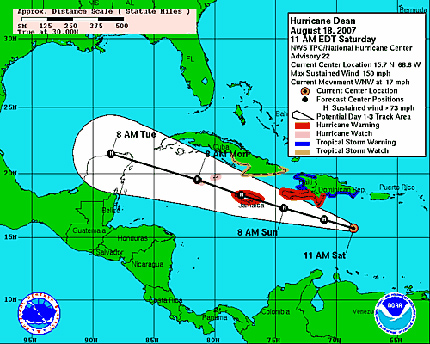
HURRICANE DEAN ADVISORY NUMBER  22…CORRECTED
NWS TPC/NATIONAL HURRICANE CENTER MIAMI FL   AL042007
1100 AM AST SAT AUG 18 2007

…CORRECTED MAXIMUM SUSTAINED WINDS PARAGRAPH…

…DEAN’S FURY THREATENS HAITI…JAMAICA AND THE CAYMAN
ISLANDS…HEAVY SQUALLS ALREADY APPROACHING HISPANIOLA…

AT 11 AM…1500 UTC…THE GOVERNMENT OF JAMAICA HAS ISSUED A
HURRICANE WARNING FOR JAMAICA.  A HURRICANE WARNING MEANS THAT
HURRICANE CONDITIONS ARE EXPECTED WITHIN THE WARNING AREA WITHIN
THE NEXT 24 HOURS.  PREPARATIONS TO PROTECT LIFE AND PROPERTY
SHOULD BE RUSHED TO COMPLETION.

A HURRICANE WARNING REMAINS IN EFFECT FOR THE SOUTH COAST OF THE
DOMINICAN REPUBLIC FROM BARAHONA WESTWARD TO THE HAITI-DOMINICAN
REPUBLIC BORDER…AND FOR THE SOUTHWESTERN PENINSULA OF HAITI FROM
THE HAITI-DOMINICAN REPUBLIC BORDER TO PORT-AU-PRINCE.

A TROPICAL STORM WARNING REMAINS IN EFFECT ALONG THE SOUTH COAST OF
THE DOMINICAN REPUBLIC FROM CABO ENGANO WESTWARD TO BARAHONA…AND
FOR COAST OF HAITI NORTH OF PORT-AU-PRINCE TO THE NORTHERN
HAITI-DOMINICAN REPUBLIC BORDER.   A TROPICAL STORM WARNING MEANS
THAT TROPICAL STORM CONDITIONS ARE EXPECTED WITHIN THE WARNING AREA
WITHIN THE NEXT 24 HOURS.

AT 11 AM…1500 UTC…THE GOVERNMENT OF THE CAYMAN ISLANDS HAS
ISSUED A HURRICANE WATCH FOR THE CAYMAN ISLANDS. A HURRICANE WATCH
MEANS THAT HURRICANE CONDITIONS ARE POSSIBLE WITHIN THE WATCH
AREA…GENERALLY WITHIN 36 HOURS.

A TROPICAL STORM WATCH IS IN EFFECT FOR PORTIONS OF CUBA…FROM THE
PROVINCE OF CAMAGUEY EASTWARD TO THE PROVINCE OF GUANTANAMO.  A
TROPICAL STORM WATCH MEANS THAT TROPICAL STORM CONDITIONS ARE
POSSIBLE WITHIN THE WATCH AREA…GENERALLY WITHIN 36 HOURS.

AT 11 AM…1500 UTC…THE TROPICAL STORM WARNING FOR THE BRITISH
VIRGIN ISLANDS…U.S. VIRGIN ISLANDS AND PUERTO RICO HAS BEEN
DISCONTINUED.

INTERESTS ELSEWHERE IN THE CENTRAL AND WESTERN CARIBBEAN…INCLUDING
WESTERN CUBA…THE CAYMAN ISLANDS…AND THE YUCATAN PENINSULA OF
MEXICO…SHOULD CLOSELY MONITOR THE PROGRESS OF DEAN.

FOR STORM INFORMATION SPECIFIC TO YOUR AREA…PLEASE MONITOR
PRODUCTS ISSUED BY YOUR LOCAL WEATHER OFFICE.

FOR STORM INFORMATION SPECIFIC TO YOUR AREA…INCLUDING POSSIBLE
INLAND WATCHES AND WARNINGS…PLEASE MONITOR PRODUCTS ISSUED
BY YOUR LOCAL WEATHER OFFICE.

AT 1100 AM AST…1500Z…THE CENTER OF HURRICANE DEAN WAS LOCATED
NEAR LATITUDE 15.7 NORTH…LONGITUDE 68.6 WEST OR ABOUT 565 MILES…
910 KM…EAST-SOUTHEAST OF KINGSTON JAMAICA AND ABOUT 210 MILES…
340 KM…SOUTH-SOUTHEAST OF SANTO DOMINGO IN THE DOMINICAN REPUBLIC.

DEAN IS MOVING TOWARD THE WEST-NORTHWEST NEAR 17 MPH…28 KM/HR. A
TRACK BETWEEN THE WEST AND WEST-NORTHWEST IS FORECAST DURING THE
NEXT 24 HOURS.  ON THIS TRACK THE CORE OF THE HURRICANE WILL BE
MOVING SOUTH OF HISPANIOLA TODAY AND EARLY SUNDAY.

MAXIMUM SUSTAINED WINDS REMAIN NEAR 150 MPH…240 KM/HR…WITH
HIGHER GUSTS.  DEAN IS A CATEGORY FOUR HURRICANE ON THE
SAFFIR-SIMPSON SCALE.  SOME FLUCTUATIONS IN INTENSITY ARE LIKELY
DURING THE NEXT 24 HOURS.

HURRICANE FORCE WINDS EXTEND OUTWARD UP TO 60 MILES…95 KM…FROM
THE CENTER…AND TROPICAL STORM FORCE WINDS EXTEND OUTWARD UP TO 205
MILES…335 KM.

LATEST MINIMUM CENTRAL PRESSURE REPORTED BY AN AIR FORCE HURRICANE
HUNTER PLANE WAS 929 MB…27.43 INCHES.

STORM TOTAL RAINFALL AMOUNTS OF 5 TO 10 INCHES CAN BE EXPECTED OVER
JAMAICA…WITH MAXIMUM AMOUNTS OF UP TO 20 INCHES.  AMOUNTS OF 2 TO
3 INCHES CAN BE EXPECTED OVER THE DOMINICAN REPUBLIC AND HAITI WITH
AMOUNTS UP TO 6 INCHES POSSIBLE.  ADDITIONAL RAIN ACCUMULATIONS OF 1
TO 2 INCHES ARE POSSIBLE OVER PUERTO RICO…WITH ISOLATED STORM
TOTAL AMOUNTS OF 5 INCHES. THESE RAINS COULD CAUSE LIFE-
THREATENING FLASH FLOODS AND MUDSLIDES.

REPEATING THE 1100 AM AST POSITION…15.7 N…68.6 W.  MOVEMENT
TOWARD…WEST-NORTHWEST NEAR 17 MPH.  MAXIMUM SUSTAINED WINDS…150
MPH.  MINIMUM CENTRAL PRESSURE…929 MB.

AN INTERMEDIATE ADVISORY WILL BE ISSUED BY THE NATIONAL HURRICANE
CENTER AT 200 PM AST FOLLOWED BY THE NEXT COMPLETE ADVISORY AT 500
PM AST.

August 18th, 2007

150 mph hurricane expected in 36 hours

dean8am18.jpg

From the Met Service ….

August 18, 2007 @ 8:00 a.m.

BULLETIN No. 7

HURRICANE WATCH STILL IN EFFECT AS DEAN ENTERS CENTRAL CARIBBEAN

A Hurricane Watch remains in effect for Jamaica as dangerous Hurricane Dean moves over the central Caribbean Sea and closer to the island. This means that hurricane conditions still pose a possible threat within 36 hours.

At 7:00 a.m. the centre of Hurricane Dean was located near Latitude 15.4 degrees North, Longitude 67.9 degrees West. This is about 400 km (250 miles) south-southeast of Santo Domingo, Dominican Republic, or 920 km (575 miles) east-southeast of Morant Point, Jamaica.

Dean continues to move westward near 28 km/h (17 mph) and a general west to west-northwestward motion is expected during the next 24 hours.

Maximum sustained winds are near 240 km/h (150 mph), with higher gusts. Dean is now a dangerous Category 4 hurricane on the Saffir-Simpson Scale and further strengthening is forecast during the next 24 hours. Hurricane force winds extend outward approximately 95 km (60 miles), while tropical storm force winds extend as far as 335 km (205 miles) from the centre.

The eye of Hurricane Dean is being forecast to move south of the Dominican Republic today and south of Haiti tonight before tracking across Jamaica during the afternoon on Sunday. Outer bands of the hurricane could, however, start affecting the island by late tonight with increasing cloudiness, showers and gusty winds.

All small craft operators, including fishers on the cays and banks, should by now have completed all the necessary safety precautions and are advised to remain in safe harbour until all warning messages have been lifted and wind and sea conditions have returned to normal.

It is likely that a Hurricane Warning could be issued in the next Bulletin as the Meteorological Service continues to monitor the progress of Hurricane Dean. All interests should pay special attention to subsequent Releases.

The next Bulletin on Hurricane Dean will be issued at 11:00 a.m.